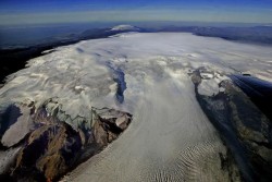
Katla Volcano
Katla is one of the largest volcanoes in Iceland. It is situated to the north of Vík í Mýrdal and to the east of the smaller glacier Eyjafjallajökull.
Katla's peak reaches 1,512 metres (4,961 ft) and is partially covered by the Mýrdalsjökull glacier. The system has an area of 595 km2 (230 sq mi). The Eldgjá canyon is part of the same volcanic system.
Sixteen eruptions have been recorded for Katla since 930. The last major eruption started on 12 October 1918 and lasted for 24 days.
Sixteen eruptions have been recorded for Katla since 930. The last major eruption started on 12 October 1918 and lasted for 24 days.
Selecione o idioma
Selecione a moeda
Euro
EUR - €
Icelandic Króna
ISK - kr
United States Dollar
USD - $
Australian Dollar
AUD - $
Canadian Dollar
CAD - $
Swiss Franc
CHF -
Chinese Yuan
CNY - ¥
Czech Republic Koruna
CZK - Kč
Danish Krone
DKK - kr
British Pound Sterling
GBP - £
Hong Kong Dollar
HKD - $
Israeli New Sheqel
ILS - ₪
Japanese Yen
JPY - ¥
South Korean Won
KRW - ₩
Norwegian Krone
NOK - kr
Russian Ruble
RUB - ₽
Saudi Riyal
SAR - SR
Swedish Krona
SEK - kr
Singapore Dollar
SGD - $
Thai Baht
THB - ฿

 English
 Deutsch
 Français
 Español
 Italiano
 Dansk
Dansk Polski
 Português
 日本語
日本語 Svensk
 Nederlands
 Norsk
Norsk 中文
中文 한국어
한국어