
When most visitors land at Keflavík International Airport, the instinct is to head straight for Reykjavík. The Reykjanes Peninsula, stretching all around the airport, is often left as little more than scenery glimpsed from the highway. That is a mistake.
Reykjanes is Iceland in miniature. It has lava fields, steaming geothermal valleys, sea cliffs, fishing towns, and the world-famous Blue Lagoon. More than that, it sits on the Mid-Atlantic Ridge, where two continents slowly pull apart. In other words: geology in action, right under your feet.
The peninsula is also recognized as the Reykjanes Geopark, a UNESCO-listed site that protects this dramatic volcanic landscape. For travelers, it offers a half-day to full-day road trip that is easy to drive and endlessly rewarding.
Highlights of the Reykjanes Peninsula
- Distance: Loop from Keflavík, 3–4 hours driving
- Best for: A first-day road trip straight from the airport
- Top stops: Blue Lagoon, Reykjanesviti Lighthouse, Gunnuhver hot springs, Bridge Between Continents, Grindavík, Kleifarvatn, Krýsuvík
- Car type: Regular car in summer, 4x4 recommended in winter
- Time plan: Half day for highlights, full day for relaxed pace
- Safety tip: Check the weather guide and road conditions
- Why go: Lava fields, hot springs, sea cliffs, and lighthouses close to KEF
Why Reykjanes Matters
The peninsula is not just convenient, it is essential.
- Geology: Reykjanes is one of the few places where the Mid-Atlantic Ridge is visible above sea level. Recent eruptions in 2021, 2022, 2023, and 2024 reshaped parts of the landscape. Walking here is like standing on the seam of the Earth.
- History: Lighthouses, shipwrecks, and fishing towns tell the story of Icelanders who lived on the edge of the Atlantic.
- Accessibility: Keflavík Airport sits at its heart. You can land, pick up a rental car, and within minutes be on the road through lava fields.
Many travelers save Reykjanes for the last day before their flight. The smart move is to start here instead. It shakes off jet lag, introduces you to Icelandic roads, and gives a taste of everything the island offers.
The Reykjanes Peninsula Driving Itinerary
This loop begins and ends at Keflavík Airport. With no stops, the drive takes about three to four hours. With sightseeing, photos, and a soak in the lagoon, plan for a full day.
Stop 1: The Blue Lagoon
The Blue Lagoon
The Blue Lagoon is the most famous attraction on the Reykjanes Peninsula, and one of the most photographed geothermal pools in the world. Its pale blue water set against black lava fields has become an icon of Iceland, a place where science, nature, and design all meet.
The lagoon itself is not a natural hot spring. It formed in the late 1970s when wastewater from the Svartsengi geothermal power plant began pooling in nearby lava fields. Locals noticed that swimming in the mineral-rich water left their skin softer, and by the 1980s people were traveling here specifically for its healing qualities. The silica suspended in the water gives it its milky color, while the algae and minerals are said to soothe skin conditions.

For many visitors, the Blue Lagoon is their first taste of Iceland after landing at Keflavík. It can be busy, but timing makes all the difference. Early morning visits mean quieter pools, with steam rising into cool air before the tour buses arrive. Late evening, especially in winter, the lagoon feels calmer and more intimate, with dark skies overhead and the possibility of northern lights flickering above the steam.
The experience is more than just soaking. There are saunas carved into lava, silica mud masks available at swim-up bars, and in-water massages for those who want the full spa treatment. Restaurants onsite range from casual cafés to fine dining with views over the lava fields.
Practical tips help make the most of your visit. Always book in advance, as time slots sell out quickly. Bring a swimsuit but leave jewelry behind, as the silica can tarnish silver. If you have long hair, apply conditioner before swimming — the minerals can make it stiff if left untreated.

The Blue Lagoon is sometimes criticized as too commercial, but it remains unique. Nowhere else can you float in warm water surrounded by fresh lava, with geothermal power stations quietly humming in the background. It is a reminder of how Iceland harnesses its volcanic energy not only to produce electricity but also to create one of the world’s most famous spas.
For those seeking wilder alternatives, the guide to natural hot springs highlights hidden pools across the country. But even if you prefer remote springs, the Blue Lagoon is worth experiencing once — not just for the water, but for what it represents: the intersection of Icelandic nature, ingenuity, and design.
Stop 2: Reykjanesviti Lighthouse and Gunnuhver
Reykjanesviti is Iceland’s oldest lighthouse site. The current tower dates to 1929, rebuilt after earthquakes damaged the original. The cliffs here are dramatic, with views toward the sea stacks of Karlinn and Eldey.
Nearby lies Gunnuhver, Iceland’s largest mud pool. The ground shakes, steam vents roar, and boardwalks allow safe access. This is the raw energy of the Reykjanes volcano system up close.
„Tvímælalaust myndi ég mæla með heimsókn að Reykjanesvita og nágrenni. Þar eru fjölmargar náttúruperlur á sama fleti. Þarna er frábært sjávarútsýni með Karlinn og Eldey í baksýn, ásamt vitanum sjálfum og sýningu í vitavarðahúsinu. Steinsnar frá er svo Gunnuhver sem er háhitasvæði í heimsklassa.“
Eyþór Sæmundsson, Media Project Manager – Visit Reykjanes“I would absolutely recommend a visit to Reykjanesviti and its surroundings. There are several natural gems in one place. The sea views are spectacular, with Karlinn and Eldey in the background, along with the lighthouse itself and the exhibition in the keeper’s house. Just a stone’s throw away is Gunnuhver, a world-class geothermal area.”

Stop 3: The Bridge Between Continents
The Bridge Between Continents
The Bridge Between Continents is one of the simplest stops on the Reykjanes loop, but also one of the most symbolic. Here, a short footbridge spans a sandy fissure where the North American and Eurasian tectonic plates drift apart. Crossing the bridge takes only a few seconds, but the idea of walking from one continent to another makes it unforgettable.
The Mid-Atlantic Ridge runs the length of the ocean floor, but only in Iceland does it break the surface. On the Reykjanes Peninsula, that ridge is plain to see. The fissure beneath the bridge widens each year as the plates slowly pull apart, leaving a scar in the earth that will eventually reshape the entire landscape.
For travelers, the site is accessible and easy. A small parking lot leads to the bridge, and signs explain the geology in both Icelandic and English. Children especially love the novelty of straddling “two continents,” and adults often pause to reflect on the scale of time and movement involved.

The best time to visit is when the light is soft — early morning or late afternoon — when shadows highlight the rift’s contours. The wind here can be fierce, so bring a jacket even in summer. The visit is quick, often no more than fifteen minutes, but it helps place the rest of Reykjanes into context. You are not just driving through lava fields and hot springs, you are standing on the edge of a planet slowly pulling itself apart.
The Bridge Between Continents is sometimes overlooked compared to the Blue Lagoon or Gunnuhver, but it deserves its place in the itinerary. It is a reminder that the drama of Reykjanes is not only in its steam and cliffs, but also in the invisible, patient movement of the earth itself.
Stop 4: Grindavík
Grindavík is more than a fishing town. It is a community that has lived for centuries on the line between sea and fire. The ocean shaped its economy, while volcanic forces shaped its land. To visit is to glimpse daily Icelandic life, far from Reykjavík’s crowds.
The harbor is the heart of Grindavík. Fishing boats line the docks, seabirds circle overhead, and the air is thick with the smell of salt and diesel. This is not a polished tourist stop, but a real working town. If you pause for lunch, you will find fish so fresh it was swimming that morning. Plokkfiskur, a traditional mashed fish stew, is a local favorite, but even a simple plate of fish and chips by the harbor tells the story of the sea.

For those curious about history, the Icelandic Saltfish Museum explains how dried cod once fueled Iceland’s entire economy. Grindavík was tied into trade routes stretching across Europe, proof that this small town mattered on a global scale.
A short stop can be rewarding, but Grindavík also makes a good base if you want to linger. Guesthouses here are quieter and less expensive than Reykjavík, and you are only minutes from the Blue Lagoon and the geothermal drama of Gunnuhver.
Timing matters. Daytime is best for a harbor meal and a museum visit, while summer evenings bathe the waterfront in long northern light that feels endless. In winter, the story is different. Grindavík has faced evacuations during the recent eruptions on Reykjanes, when lava crept dangerously close to town. Roads can close and conditions shift quickly, so always check weather and safety updates before setting out.
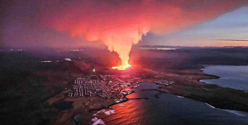
In late 2023 and early 2024, fissures opened near Grindavík. Lava threatened homes, and for weeks residents lived in uncertainty, evacuating at night and returning by day to protect what they could. Barriers were built, and much of the town endured. That resilience defines Grindavík. It is not only a place to eat or stop on a drive, but a window into how Icelanders adapt to a land that is still being created beneath their feet.
Stop 5: Kleifarvatn and Krýsuvík
Kleifarvatn is one of the deepest lakes in Iceland, surrounded by steep volcanic slopes that look almost otherworldly. The water is dark, still, and often reflects the clouds above like a mirror. After a series of earthquakes in 2000, fissures opened beneath the lake and the water level dropped dramatically. Scientists later discovered that Kleifarvatn leaks directly into underground lava channels, a reminder that nothing in Iceland’s landscape is permanent.
The lake is wrapped in stories as well as science. Locals once told of a monster living in its depths, a serpent-like creature said to rise on misty mornings. Whether you believe the tale or not, the atmosphere of Kleifarvatn lends itself to imagination. Standing on its shores, especially in the quiet of early morning or evening, you feel both the scale of nature and the mystery it holds.

A short drive away lies Krýsuvík, also called Seltún, one of the most colorful geothermal areas in Iceland. Wooden boardwalks wind through steaming vents and bubbling mud pools, the ground stained with reds, yellows, and greens from mineral deposits. The smell of sulfur is sharp, the air warm even in winter, and the hiss of steam vents is constant. It is a place that engages all the senses.
Krýsuvík has long drawn interest from scientists studying geothermal energy, but for travelers it is the colors and sounds that leave the strongest impression. Visit in the early morning when steam rises into cold air, or at sunset when the light turns the hills golden. For photographers, it is one of the most rewarding spots in the entire Reykjanes Geopark.
Together, Kleifarvatn and Krýsuvík show the two faces of Reykjanes: the stillness of volcanic lakes and the restless energy of geothermal fields. They are proof that the peninsula is more than a detour from the airport — it is a landscape where fire and water, myth and geology, meet in the open air.
Driving Tips and Practical Advice
- Seasons: In summer, roads are clear and any car will do. In winter, book a 4x4.
- Road rules: Headlights always on, seatbelts for all. Speed limits: 50 km/h in towns, 80 km/h on gravel, 90 km/h on paved roads. Full details in our traffic law guide.
- Weather: It changes quickly. Always check the weather guide.
- Safety: Use marked pull-outs for photos. Icelandic winds are strong enough to rip a car door off its hinges.
- Packing: Even in July, a windproof jacket is essential. In winter, pack ice grips for shoes.
Best Time to Visit Reykjanes
- Summer (June–August): Long daylight hours, mild temperatures, easy driving conditions. Great for relaxed exploration and photography.
- Winter (November–March): Short days, icy roads, potential for northern lights. A 4x4 rental is highly recommended.
- Shoulder seasons (spring and autumn): Fewer crowds, changing colors, and lower prices on accommodation. Weather is unpredictable but rewarding.
Expert Voices on Reykjanes
“Reykjanes is one of the most active volcanic zones in Iceland. Visitors often expect it to feel static, but the land is still shifting today.”
Sigurðsson, Volcanologist
“Many travelers skip Reykjanes on their way to Reykjavík. They should not. In just a few hours you can see cliffs, lava fields, hot springs, and the Atlantic. It is Iceland in fast forward.”
Anna Kristín, a Licensed Guide
“The Blue Lagoon is best early in the morning or late in the evening. That is when the pools are calmer, and you can enjoy the contrast between the warm water and the raw lava.”
María, a Guest Experience Manager
“Steam at Krýsuvík looks completely different at sunrise compared to sunset. If you have one evening free, take your camera there.”
Ólafur, a Landscape Photographer
Final Word
The Reykjanes Peninsula is not just where your flight lands. It is where the Atlantic collides with volcanic fire, where fishing towns face the ocean, and where Iceland shows its power in a compact package.
Start your trip here, and you will begin with a true sense of place: lava underfoot, steam in the air, and cliffs dropping into the North Atlantic. Whether you take a guided tour or design your own Reykjanes Peninsula itinerary, this loop is the perfect introduction to Iceland.
Begin simply. Grab a rental car, follow the loop, and let Reykjanes set the tone for the adventure ahead.