
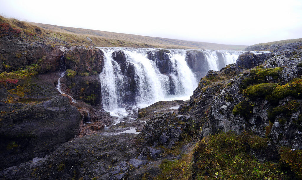
The Ring Road is a very popular route with tourists due to its relative simplicity and the fact it covers a large number of major attractions here in Iceland. The route is a great starting point for many travelers as it loops along the coast, around the entire island.
As you travel, you can take regular detours from the road to any of the multiple attractions found along the road.


This blog post will detail some of the usual attractions that are visited by people traveling the ring road, as well as some slight detours and hidden gems that I believe may be worth visiting. The recommended length-of-stay to fully experience the ring road is anywhere from 7 to 11 days. Whilst it is possible to do it in less, that may be a bit too rushed. It is best to take your time, fully experience the attractions and also see the lesser-known sights that Iceland has to offer.
- The Ring Road is 1322km or ~821 miles long.
- Also known As Route 1 and circles the whole island.
- Recommended time driving the Ring Road is at least 7 days.
- You can drive it in one day but that means missing out on beautiful landscapes and photographic opportunities.
- Vast majority of the highway is paved and two-lane with some unpaved stretches along the way as well as one-lane bridges.
- You can drive on a compact family car, 4x4, Camper or any type of vehicle without problem. Most like to use 4x4 or a Camper to be able to stop anywhere and rest, as well as reach destinations that some cars cannot.
- Plan ahead if you need accommodations around the Ring Road as it is a very popular drive and some hotels or campsites might be overbooked in high season.
South West Iceland
Golden Circle
Probably the most traveled route in Iceland, the Golden Circle is a 300-km route that takes you to 3 destinations: Þingvellir National Park, Geysir Geothermal Area, and Gullfoss Waterfall. There are a lot of activities to engage in along the route as well, such as a unique snorkeling experience in a clear-as-glass continental rift.
Þingvellir
The first stop on the Golden Circle is 'Þingvellir National Park', the home of the Icelandic parliament 'Alþingi' from the 10th to the 18th century. The area is full of history, In fact, the þingvellir church is still standing and the ruins of old stone buildings can still be seen and now, Þingvellir is a UNESCO World Heritage Site.

Around a 45-minute drive from Reykjavik, Þingvellir is situated directly between the North American and Eurasian tectonic plates. The continued separation of these plates, around 2.5 centimeters each year, is the reason for Iceland's high volcanic activity. This has also led to the forming of ravines that are then filled with the meltwater from the Langjökull glacier. The water is often crystal clear, an example being that of the popular diving and snorkeling spot, Silfra.
The water at Silfra sits at around 2°c and has a visibility of up 120 meters. Don't worry if it sounds cold, the dive team that operates at Silfra offers dry suits as part of the snorkeling tour. The snorkeling tours are available to everyone, however, for those of you that wish to dive then you must already be a qualified PADI Open Water Scuba Diver.
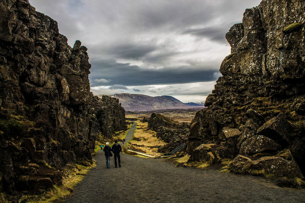
Some of the ravines have also avoided being filled with water, with the most popular being Almannagjá gorge. For those of you that watch the hit series 'Game of Thrones' then this area will be a familiar site. The scenes between Arya Stark and The Hound in the Riverlands were shot here. The gorge is created by the Earth literally ripping apart, and it's possible to walk in between. If you continue on the walk you will end up at the majestic Öxarárfoss waterfall.
Geysir
Next up is Geysir, the Geothermal area located within the Haukadalur Valley. Geysir is around a 55-minute drive from Þingvellir. On the drive from Þingvellir to Geysir, you will see the geothermal activity slowly increase, notably through steaming vents.
On the route, you will also pass the Laugarvatn Fontana Spa which is heated by the hot water that flows below the ground. In fact, the steam bath there is directly heated from one of the hot pots, reaching temperatures between 40-50°c.

When you get to Geysir, you will be pleasantly surprised by the level of geothermal activity. The whole area is covered with hot pools, steaming vents and fumaroles. And then, of course, you have the geysers themselves. The first one is literally called 'Geysir' and is the earliest documented geyser in European literature, though Geysir is almost completely inactive these days due to both the tectonic activity of the area and apparent human intrusion. Its last eruption took place in 2016.
Geysir does have a little sibling, who goes by the name of 'Strokkur'. Thankfully, Strokkur makes up for Geysir's inactivity by erupting nearly every 5 to 10 minutes at a height of 15 to 20 meters, although it has been known to reach 40 meters.
Gullfoss
The final stopping point on the Golden Circle is Gullfoss, otherwise known as 'The Golden Falls'. This majestic two-tier waterfall stands at a height of 32 meters, whilst its heaviest water flow has been known to reach 140 cubic meters of water per second.
The waterfall is viewed from a viewing point that overlooks the waterfall, whilst during the summer it is also possible to walk down to a closer viewing point where you can get up close and personal with Gullfoss. However, the lower viewing point is closed during the winter months due to the high chance of slipping.

Glymur
Whilst Þingvellir, Geysir and Gullfoss are the key trio of the Golden Circle there are also some great detouring options available in the local area. The most popular of those is the gigantic waterfall 'Glymur'. Previously regarded as the largest waterfall in Iceland, before being surpassed by the recently discovered Morsárfoss, Glymur is located around 45-minutes from Reykjavik in the Hvalfjörður area.
What adds to Glymur's uniqueness is that you can hike around the waterfall and even cross through the Botnsá river that it stems from. Most people will hike to the viewing point and back down, however, it is also possible to continue onwards. Though the route does become more difficult afterward. You will be required to climb and even use a rope to 'wall-scale'. If you enjoy hiking then Glymur is definitely a location you won't want to miss.
_____
South Coast
Commonly, people will travel the ring road counter-clockwise. So, the next region would be the south coast. The south is packed with attractions and this is why some people may just stay in the South for the entirety of their stay. There are waterfalls, glaciers, volcanoes and even a black sand beach. You can take South Coast Tours or drive the area yourself as everything is easily accessible.
Seljalandsfoss
Seljalandsfoss is usually the first stopping point on the south coast, and also probably the most famous waterfall in Iceland. This is because you are able to walk behind the waterfall, though the spray may lead to you getting very wet! The spray can also pose a danger during the winter as the path may become very slippery, so be very careful if you are visiting during the winter months because chances are the water will freeze.

Skógafoss
Situated around a 30-minute drive from Seljalandsfoss, Skógafoss is another popular waterfall in the South. In fact, Seljalandsfoss and Skógafoss go hand-in-hand and are always part of the same tours. It's very rare for a person to view one without the other. For the Beliebers out there, you may also recognize Skógafoss and Seljalandsfoss from Justin Bieber's music video for his song "I'll show you".
Skógafoss stands at around 60 m high, and you can walk right up to the waterfall. Though, similarly to Seljalandsfoss, be prepared to get very wet! Most people will tend to view the waterfall from the side or you can even take the many, many... many steps to the top where there is a viewing point that overlooks the waterfall.
Gljúfrabúi
Alongside these 2 popular waterfalls are some lesser known ones, all located within close proximity of Seljalandsfoss and Skógafoss. The first of those is Gljúfrabúi which is a 10-minute walk from Seljalandsfoss. Hidden deep inside a cleft in a cliff, Gljúfrabúi requires you to walk through the Gljúfurá river in order to access the falls. There is a gigantic boulder in front of Gljufrabúi and this is where many Instagram models will choose to take their wanderlust-inspiring photos.
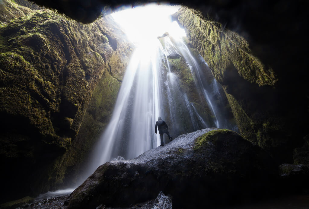
Kvernufoss
Located on the East side of Skógafoss, behind the Skógar museum, is Kvernufoss. It is situated within close proximity of the road but is hidden by cliffs and a gorge. To get to this hidden gem you first need to take a very simple 20-minute hike. The hike will lead you into a gorge where a beautiful river flows through, once you get to the gorge you will now finally be able to see Kvernufoss.
Similar to Seljalandsfoss, it is possible to walk right behind the waterfall and the best part is that because Kvernufoss is much lesser-known, you will most likely have the falls all to yourself.
Sólheimasandur Plane Wreck
Continuing along the South Coast, you will come across one of the most photographed and unique locations in Iceland: The Sólheimasandur Plane Wreck. Iceland is a NATO member and up until 2005, the US army had bases situated on the island. The plane crash took place on November 21st 1973, thankfully none of the 7 passengers was injured but it is still unknown as to why the plane did crash.
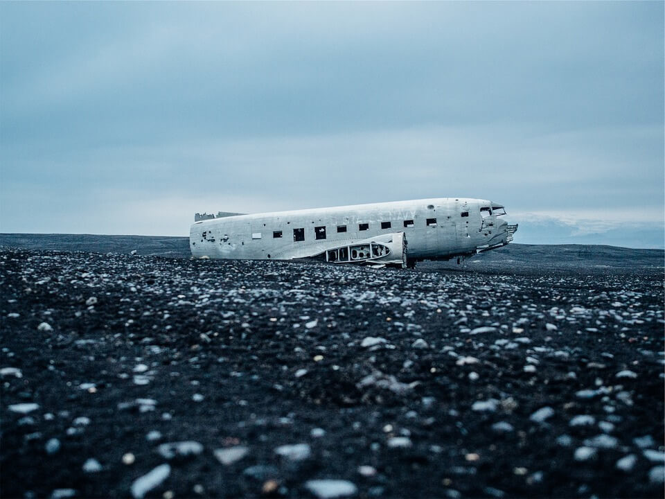
Since then the plane has begun to erode, with the nose, wings and tail now completely gone. Although, there was a rumour that a local farmer cut off the tail many years ago in order to cash in on the material.
The plane wreck is a very unique attraction and is steeped in the history of Iceland, however, chances are it won't be around much longer. It is located close to the glacier 'Mýrdalsjökull' which covers Katla. This poses a lot of problems as Katla is said to be overdue an eruption, and if Katla were to erupt it could send the meltwater from Mýrdalsjökull en route to Sólheimasandur.
Reynisfjara Beach (Black Sand Beach)
Reynisfjara Beach, another location that may look familiar to 'Game of Thrones' fans, is a black sand beach that is both beautiful and extremely dangerous. The waves can be very unpredictable and this has led to many unfortunate injuries and even death. There are signs that instruct you to stay away from the coastline, and we recommend you do so!
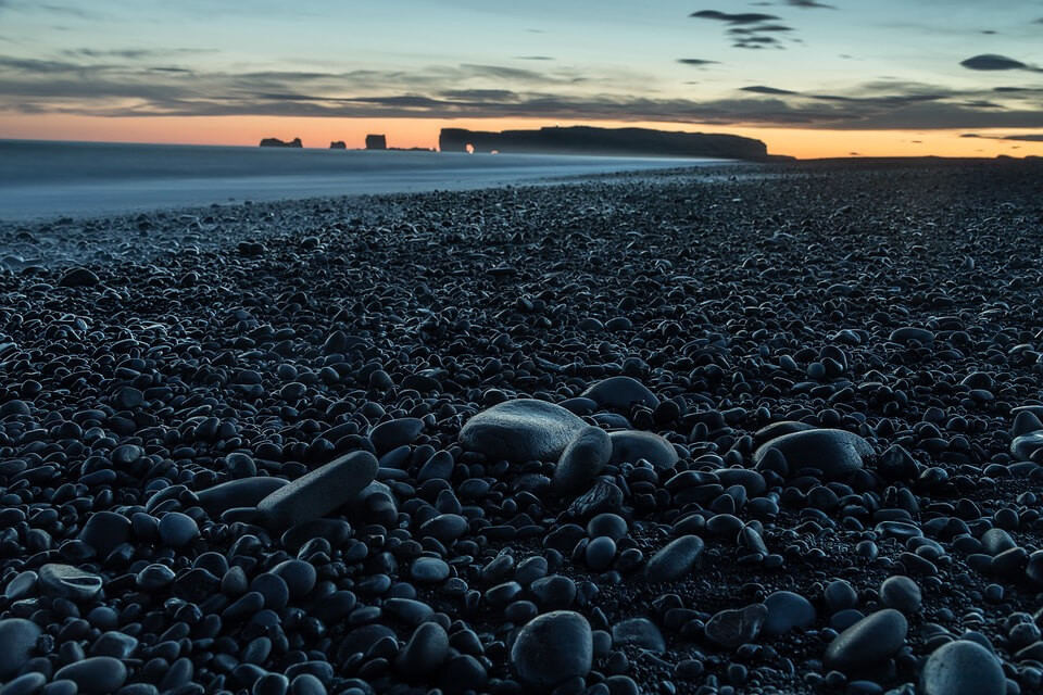
The beach is full of unique shapes and sights, including the Reynisdrangar columns, which are freestanding sea stacks just off of the Reynisfjara coast. The largest column has peaks and is called Langsamur, then the 2 smaller columns are called Landdrangur and Skessudrangur. The columns are the result of eroding following the last ice age, it is thought they were part of the mountain next to them.
Along the beach is also a stunning basalt columned wall and within this wall, you will see a cave that was naturally formed. The cave is very popular with tourists, especially when it is raining as people hide in the cave and view the beach from afar. Funnily enough, many sheep have been found inside the cave. I don't blame them, standing out in the rain all day must get pretty tiring.
Eastern South Coast
Typically, any traveler that visits the south coast they will always head to the popular town of Vík. Situated as the Southernmost town on the mainland of Iceland, Vík or 'Vík Í Mýrdal' is popular due to it being within close proximity of most Southern-based attractions. It is also the starting point for a lot of glacier tours and sits opposite the above mentioned Reynisfjara Beach.
Vík may also be popular for the bird watchers out there as the many cliffs mean that birds are very present, especially during the summer months. In fact, Puffins have been seen in the area on occasion.
As well as the birds, you may also spot a seal from Reynisfjara and also whales have been known to be spotted from a distance.

Vík is a great spot to stop overnight for those of you driving the ring road, there are many different services available and you can find hotels, hostels and guesthouses there so no matter your budget you will find something suitable.
There is also a gas station, shops, cafes, a swimming pool and a very popular wool factory where you can purchase different types of wool for those who enjoy knitting. You can also purchase one of the popular Lopapeysa, the Icelandic wool sweaters.
Fjarðrárgljúfur
Next up on the Ring Road, is the Fjaðrárgljúfur canyon. Sitting at around 100m deep and 2km long, this canyon has continued to grow in popularity. It is easily accessible from the ring road, look for the sign and then follow road 206 that leads from road 1.
Part of the road is gravel but is accessible in both a 2WD and 4WD, however, during the winter months, I would recommend only heading there if you have a 4x4.

You will reach a car park where you can pull up and overlook the canyon, or even walk down to the canyon and get even closer. If the river is quiet then some people have even taken off their shoes and dipped their toes into the water!
The canyon is said to have formed following years of erosion from the water that flows through there from the local glaciers. Gljúfur is the Icelandic translation for Canyon, whilst Fjaðrá is the name of the river that flows between the overlooking cliffs. If you are visiting during the summer and have a raised 4x4, then you may wish to continue onwards to Lakagígar (otherwise known as 'Laki'), the volcanic fissure.
Vatnajökull National Park
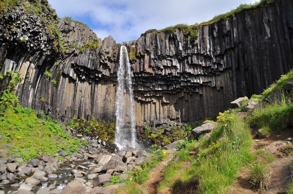
Located almost 2 hours from Vík in the Vatnajökull National Park, is the nature reserve 'Skaftafell'. In this area, you will find a large variety of different sights, from waterfalls to rock formations and also great hiking trails. All of the hiking trails lead to astonishing places, such as the one that takes you to the Hallgrimskirkja-inspiring waterfall 'Svartifoss'. You have most likely seen photos of this waterfall already, its gigantic basalt columns that surround the waterfall are something to behold.
There is a visitors center at the starting point of Skaftafell, here you can get information and maps of where all the popular attractions and hiking trails within the area are located. For the mountaineers out there, Skaftafell also serves as the perfect base camp for the people that are attempting to climb Iceland's highest peak, Hvannadalshnúkur.
____
Jökulsárlón (Glacier Lagoon)
The last, and probably the most popular stopping point on the South Coast is the glacier lagoon, Jökulsárlón. Located between the previously mentioned Skaftafell and the town of Höfn, the lagoon is conveniently placed just off of the ring road. Jökulsárlón is filled with the meltwater from Breiðamerkurjökull, the tongue of Vatnajökull, Europe's largest ice cap. The area is filled with icebergs that have broken from the glacier, with some of them of gigantic size.
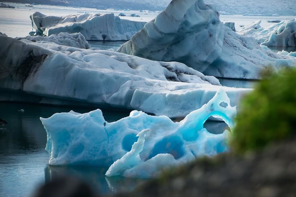
These Icebergs will often either drift out to sea or wash up on to the shore, this has led to the beach being nicknamed 'The Diamond Beach' as the ice glistens against the black sands.
Formed around 1935, Jökulsárlón has become one of Iceland's biggest tourist attractions. The area is filled with eager travellers on a daily basis.
One of the main attractions for visitors is that you can now take a boat tour, which takes you up close to the gigantic icebergs and the tour guides will even allow you to taste the ice.
Jökulsárlón has been featured in many different documentaries and movies, most notably it was in the James Bond movies 'A View to Kill' (1985) and also 'Die Another Day' (2002). Most recently you may have seen the glacier lagoon ins 2005's 'Batman Begins'.
East Iceland
Egilsstaðir
We'll start with the largest town in the East of Iceland, Egilsstaðir. Most services, grocery stores and hotels are situated here. You will also find the airport where you can take flights to and from Reykjavik. Egilsstaðir is somewhat regarded as the capital of the East and many locals will travel from smaller towns for work.
As of 2018, Egilsstaðir is home to 2464 people, with most people working in the local tourism centers, fisheries or farms. There is also an annual musical festival called Hringrás, as well as a Jazz festival.
For those of you traveling the Ring Road, you may want to use Egilsstaðir as your overnight stopping point in the East as there are many hotels, hostels and guesthouses to choose from. It is also a good location to stock up on food for the next part of your journey.
Hallormsstaðaskógur & Lagarfljót
Egilsstaðir is conveniently located close by 2 popular attractions: Hallormsstaðaskógur and Lagarfljót. The first of those is Iceland's largest forest, where there are many wildlife and hiking trails. Its popularity stems from the fact that Iceland is mostly a treeless nation so seeing a forest here is pretty unique.
Many years ago, Iceland was covered with woodland, however, the volcanic eruptions over the years have led to their disappearance. Hallormsstaðaskógur covers around 740 square kilometers, following the reforestation service of Iceland's plans to bring woodland back to Iceland.


Lagarfljót is a lake rich with history and tales. The biggest tale being that the lake is said to be the home of the 'Lagarfljót Wyrm', a cousin of the Loch Ness Monster. Though many people pass this off as folklore, over the years locals have recounted their witnessing of this beast, which has led to the creation of sculptures around the lake which depict the creature.
Seyðisfjörður
Another well-known town in the East of Iceland is Seyðisfjörður, this town has gained popularity due to its magnificent multi-coloured wooden buildings, church and the colourful rainbow street. Also, during World War 2, Seyðisfjörður was a base for allied forces.
A ship called El Grillo had docked there after being attacked by German soldiers. The captain took the decision to sink the ship after it was damaged beyond repair. The remains of the ship still rest on the sea bed and it is a very popular destination for divers.
The town is based in a gigantic fjord, this gave fishermen a great advantage over other parts of the island and therefore, led to it becoming one of the most prosperous towns in East Iceland. Still popular for its fisheries, the town has now also become a hot spot for tourists. This is due to many factors.
As mentioned before, the town is home to many brightly coloured buildings, with the most popular being 'Blákirkja', the Blue Church.

Colour, art and Seyðisfjörður seem to go hand-in-hand as many of the locals enjoy dabbling in painting and photography. In fact, an art residency was set up there in 2013 where they invite aspiring artists to come live and learn. The most popular art feature in Seyðisfjörður is by far the rainbow walking path which leads up to the aforementioned, Blue church.
Although not actually part of the Ring Road, it may be worth visiting the Eastfjords during your visit. The Fjords are huge and each one is filled with its own uniqueness and breathtaking moments.
The Eastfjords are much more rugged and mountainous than its sibling, the Westfjords. The Eastfjords consists of Seyðisfjörður, Reyðarfjörður, Álftafjörður, Stöðvarfjörður, Mjóifjörður, Eskifjörður and others.
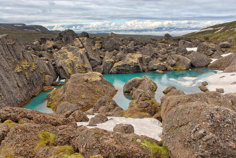

Surrounding the Fjord's you will find many different attractions. One of those is Stórurð, a great hiking spot that leads to many fascinating sights, including a lake filled with rich azure blue colored water.
As well as Stórurð, you may wish to head to Hengifoss waterfall which is situated close to Hallormsstaðaskógur and Lagarfljót. It stands at around 128 meters high and is now regarded as the 3rd highest waterfall in Iceland.
The weather in the East is always much nicer than the rest of Iceland, the summer especially. So make sure you take advantage of those rays.


North East Iceland
Dettifoss, Hverir, Dimmuborgir, Ásbyrgi & Mývatn
'The collapsing waterfall' or Dettifoss, holds the title as the most powerful waterfall in the whole of Europe. It averages around 96,500 gallons of water passing its bow every single second. It has a drop of around 45 metres and its mist can be seen from many miles away, such is its power.
Dettifoss is located north of the Ring Road. The roads to the waterfall are very rough with only one of them being paved. The Southwest route is the only route which you can take during the winter months, however, during the summer there are 3 other options.
The best of those is the Northwest route as you can stop to see Ásbyrgi and Hljoðaklettar on your way. These roads aren't F-roads but a 4x4 is advisable due to the rough gravel.

Dettifoss was featured in 2012's Ridley Scott movie, Prometheus. Since then its popularity has drastically grown. Close to Dettifoss, you will also find the smaller waterfall 'Selfoss' which is referred to as Dettifoss' little sister.
If you're an avid hiker or just looking to take a scenic walk, then walking along the Jökulsá Canyon that surrounds Dettifoss is definitely worth it as it is regarded as the most beautiful hiking experience in Iceland. The area is filled with all kinds of different attractions and sights, including the aforementioned waterfalls, Hljóðaklettar (stunning rock formations) and also Ásbyrgi.
Ásbyrgi
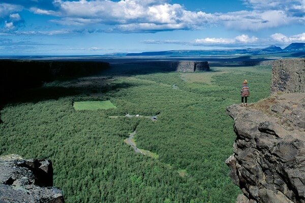
Said to be the shoeprint from the leg of Odin's Horse, Ásbyrgi is a gigantic canyon situated in the North East area of Iceland, just off of the ring road. It measures at around 3.5 kilometers in length and 1.1 kilometers in width. Surrounded by 100 meter high cliffs, Ásbyrgi is part of the 'diamond circle', the North-East's answer to the Golden Circle.
Though the folklore that tells of how Odin's horse made this canyon is interesting, I think that scientists might be right in thinking that the canyon was formed following the ice age and high amounts of glacial flooding.

Similarly to Dettifoss, Ásyrgi can be accessed by a non-4x4. However, we definitely recommend avoiding the area unless you have a car with high ground clearance as the chances of damage from the gravel road are very high. Also, Ásbyrgi can usually be inaccessible during the winter due to the heavy snowfall on the roads.
Closely located to Ásbyrgi, following a short hike, you will also find a small lake which is called 'Botnstjörn'. You can also hike to Eyjan, the cliff that divides Ásbyrgi. If you walk to the edge of the cliff, you will have a stunning view across the canyon.
Hverir
Next up in the North-East is Hverir, a large Geothermal field filled with pools of boiling mud, hot springs and steam vents. If you take a shower whilst in Iceland and the smell from the hot water makes you feel sick then Hverir is somewhere you may want to avoid. The rotten-egg-like smell is very intense in this geothermal haven, but that's just the sulphur. Hverir is definitely very reminiscent of Mars, a lot of people say this and I have to agree!
At the back of the geothermal area, you will find the mountain Námafjall. You can hike to the top on a steep trail, which is heated from the ground due to the amount of geothermal energy in the area. At the top of the mountain, you'll have a whole host of viewpoints. They all overlook different areas, including Mývatn (more on that later), lava fields, gigantic mountains in the distance and of course, Hverir itself.
You can get to Hverir after exiting the Dettifoss area and continuing west along route 1, once you hit the junction you will then see signs which direct you towards the Hverir parking lot.

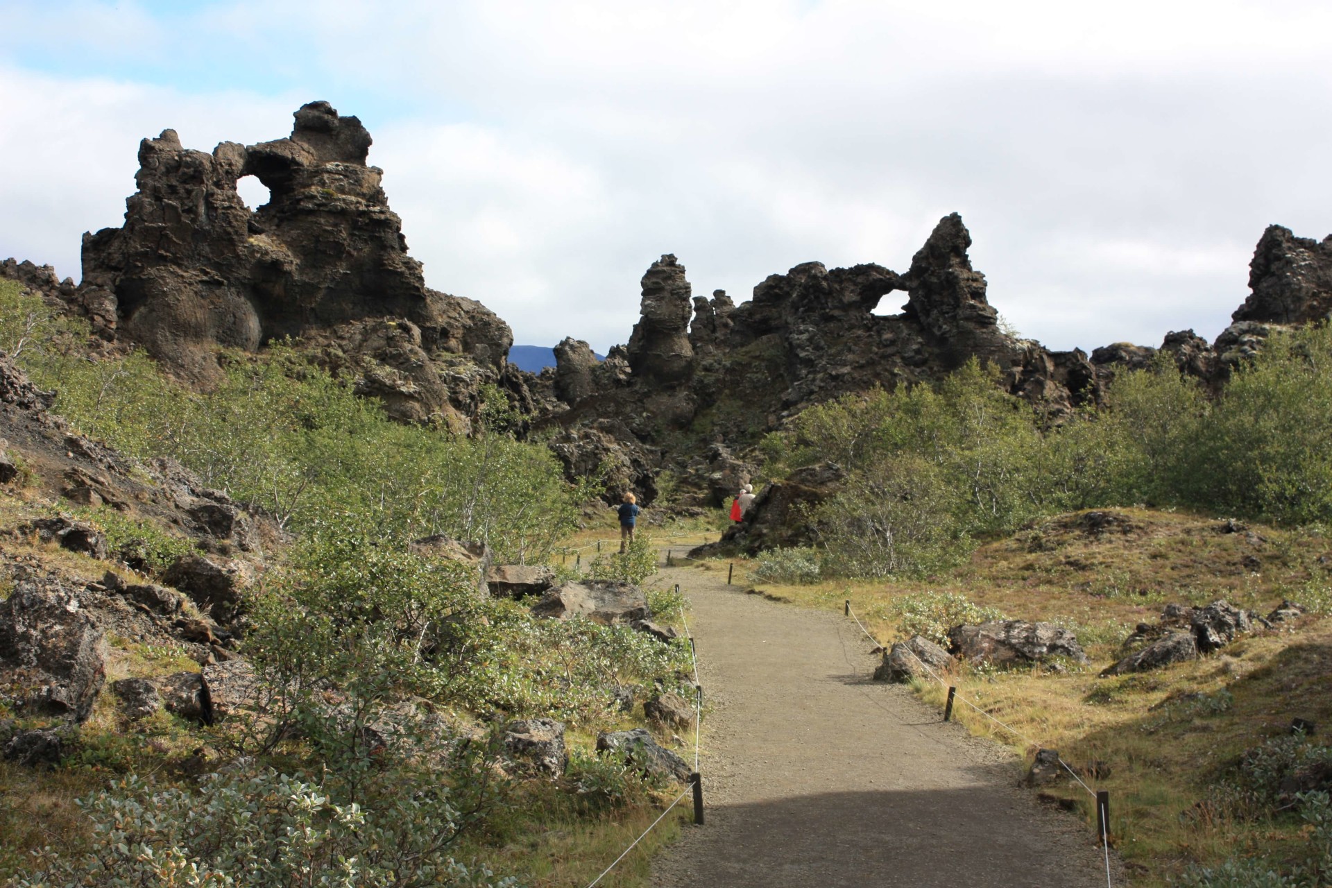
Dimmuborgir
Around a 15-minute drive from Hverir, you will find the Dimmuborgir Lava Formations. The loose translation is 'Dark Castles' because of the shape of the lava, which is reminiscent of the medieval days. The rocks are twisted, pointy, any shape you can think of, you will most likely find it there. They remind me of something dark, to the point that I'm surprised a horror movie inspired by Dimmuborgir hasn't been made.
Mývatn
Mývatn is a huge area filled with many popular attractions, the most prominent of those being the nature baths. This area is by far my most favourite in Iceland. The nature baths are a set of geothermally heated pools and steam baths. As previously mentioned, the pools are considered to be an alternative to the Blue Lagoon and in fact, more people are choosing to head to Mývatn rather than the Blue Lagoon due to its more natural feel. The floor is still filled with tiny stones and rocks, which weirdly feels very relaxing.
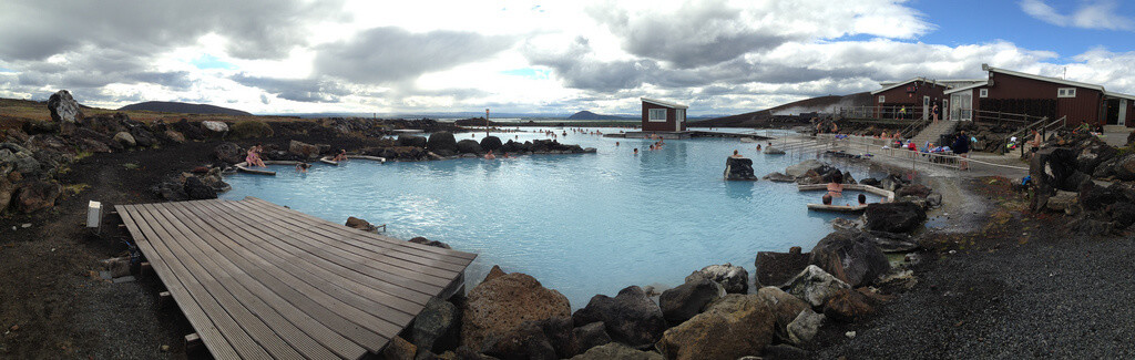
Due to Mývatn being so far from Reykjavik, there are usually far fewer people there. Though you won't be completely alone, it is definitely much more peaceful than the Blue Lagoon. During summer, try to head there late at night, the atmosphere is so surreal and I guarantee it will be a highlight of your trip.
The pool stands at around 26-40°c, and in fact, if you move around you will feel all different temperatures in different locations within the pool. The water is also filled with minerals, most notably sulfur, which is known to be good for skin treatment and respiratory issues.
At the Mývatn Nature Baths, you will also find 2 steambaths which sit directly on top of geothermal hotspots. This means that the temperature inside can reach up to 50°c. I would recommend taking water in with you as it can get extremely humid.
As I previously mentioned, Mývatn is filled with many different attractions. The first of those is the Skútustaðagígar pseudo craters. Created over 2,300 years ago, following the Lúdentarborgir and Þrengslaborgir eruptions, these craters are different from others as they have no end to them.
Craters are formed when lava flows over the wet ground. This then leads to steam being trapped under the weight which causes pressure to form the craters.
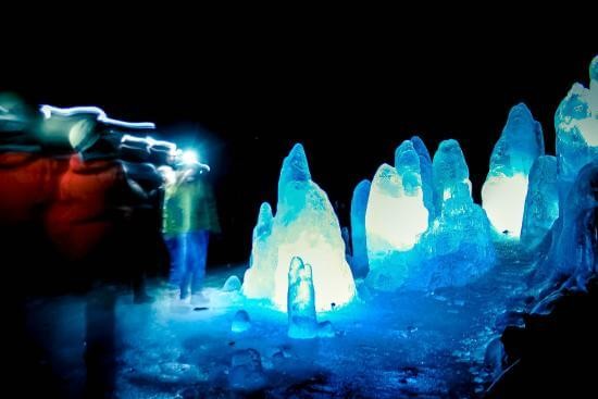
One of the most unique locations in the Mývatn area is the Lofthellir Cave. The reason why it is so unique is that it is also home to huge ice sculptures. Getting to this cave is very tricky and only recommended for people into mountaineering and physically fit.
You are required to use ropes to get into the cave, but once you get in there it is something to behold. The cave is filled with multi-coloured rocks and huge naturally formed ice sculptures.
Grjótagjá
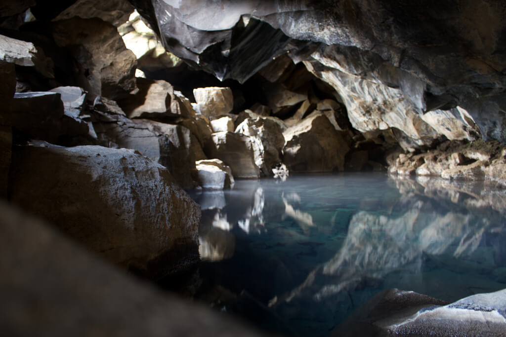
My favourite location in the Mývatn area is by far the 'Grjótagjá cave'. This cave has gained popularity in the past 5 years. Why, you ask? Because of 'Game of Thrones' of course! I think everything in Iceland has gained popularity since it appeared on TV. Anyway, this small cave is home to a stunning geothermal hot spring that has crystal clear water.
The cave is privately owned by a farmer, who asks people not to bathe in the water or wash their clothes in there. Unfortunately, this has happened and he has been forced to close it down on occasion. Grjótagjá is the cave where Jon and Ygritte had their moment of intimacy, though don't expect the beautiful waterfall as that was added with CGI. But, don't worry, everything else in the cave is just as glorious.
_____
North Iceland
Akureyri, Húsavík &
Sat comfortably in the Eyjafjörður fjord, you will find Akureyri, also known as 'The capital of the North'. Akureyri has prospered due to its fisheries, with many locals having worked in the industry over the years. Samherji, one of Iceland's largest fishing companies, is based in Akureyri.
However, its success has also led to growth and nowadays the town has the second largest hospital in Iceland as well as the booming tourism industry. Similar to Reykjavik, if you head into downtown Akureyri, you will find mostly travelers and tourist stores.
Akureyri is a great stopping point for travellers as it is situated within close proximity of most popular tourist destinations in the North of Iceland. The previously mentioned Mývatn is only a 1-hour drive away, with a further hour to the Dettifoss and Ásbyrgi area.


In downtown Akureyri, you'll find many hotels, hostels (including the popular Akureyri Backpackers), as well as cafes, restaurants and more. The most popular restaurant in Akureyri is Strikið, which has a stunning view of the harbour. Akureyri's beauty stems from the fact it is based in a gigantic fjord which makes for spectacular views.
There are many things to see and do in Akureyri, one of the most popular is Akureyrarkirkja Church. It seems like every town in Iceland has a beautiful church! Akureyrarkirkja was built in 1940 and was designed by one of Iceland's most famous architects, Guðjón Samúelsson, the person who also designed Hallgrímskirkja in Reykjavik.
The church sits halfway up a hill, where most of Akureyri is situated. Aside from the Church, a lot of people will head to Akureyri for the AK Extreme skiing and snowboarding festival that takes place on the popular skiing resort, Hlíðarfjall.
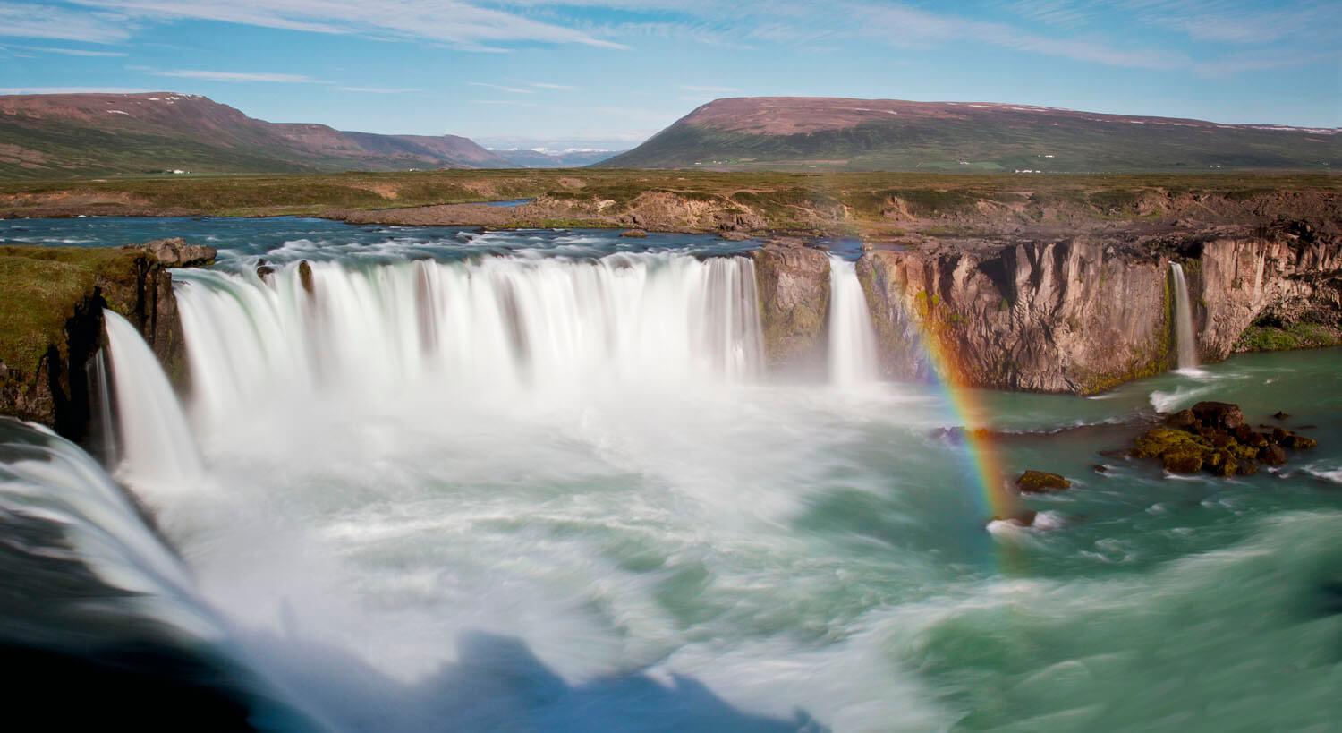
Goðafoss
One of the best attractions located close to Akureyri is Goðafoss, or 'The waterfall of the gods'. Standing at around 12 metres high and with a width of 30 metres, Goðafoss is easily one of the most spectacular waterfalls here in Iceland. It is part of the river Skjálfandafljót, which is the fourth largest river in Iceland. You can get to Goðafoss by driving east from Akureyri for around 34-minutes.
Goðafoss gets its name from an old tale, the story goes that in the year of 1000, Christianity was made the official religion of Iceland by the Lawspeaker Þorgeir Ljósvetningagoði. Upon his conversion, Þorgeir threw his statues of the Norse gods into the waterfall when returning from Þingvellir. This story comes from the artwork in the window of Akureyrarkirkja, the church in Akureyri. However, there is no official mention of it in the book of Icelandic history, 'Íslendingabók' which was written by the Icelandic priest 'Ari Þorgilsson' in the 12th century.
Húsavík
For those of you interested in going whale watching, then you could take a 1-hour drive to Húsavík where some excellent whale watching tours are located. Húsavík is also an incredibly beautiful town and has become very popular with travellers in recent years.
Húsavík is also the site of the first house built in Iceland, in the year 860, by Swedish viking Garðar Svavarsson. Húsavík is conveniently located for day trips to most of the major attractions in Iceland, part of the Arctic Coast Way and the starting point of the Diamond Circle.
Húsavík also served as the setting of the 2020 Netflix film: Eurovision Song Contest: The Story of Fire Saga and was a big inspiration for the song Húsavík, my Hometown. Have a look at the video down below if you want to have a listen.
Search for the hashtag #husavikmyhometown and you might see some inspiration for where to go about in Húsavík.
The Westfjords
Continuing counter-clockwise along the ring road from Akureyri, you will pass one of the most spectacular locations here in Iceland: The Westfjords. Now, the Westfjords aren't officially part of the Ring road, however, if you have plenty of time then I definitely recommend travelling around these beautiful fjords.
There is plenty to see and do in the area and the fjords themselves are something to behold, they make for an amazing driving experience. If you're looking to avoid the crowds then the Westfjords will be perfect for you. Despite their popularity, they are so large that you will barely see other travellers during your venture.
Ísafjörður
The so-called capital of the Westfjords is a town called 'Ísafjörður', which sits almost at the top of the Westfjords. The main industry in the Westfjords is fishing, this is due to the limited inhabitants and also it's the perfect location for fishing as most towns are based in large Fjords.
Some of my favourite towns in the Westfjords include Patreksfjörður, Bíldudalur and Suðureyri. I would recommend avoiding the Westfjords if you plan on coming during the winter as the area is not as well maintained as other parts of Iceland.

Hornstrandir
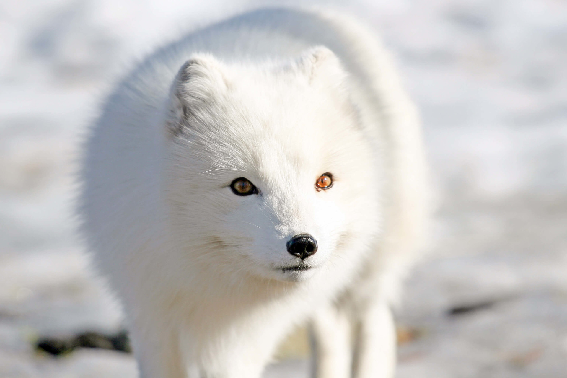
Attractions in the Westfjords include the remote nature reserve, Hornstrandir. This area has been deserted since the 1950s, with its main occupant now being wildlife, which includes the Arctic Fox. Hornstrandir is only accessible from Mid-June to late August, and to get there you need to take a ferry that departs from Ísafjörður. It's recommended that you book tickets in advance.
Due to Hornstrandir's remoteness, there are no shops, no roads, and no cars allowed. There are many stunning hiking trails over the area, with the most popular being a 3-day hike, beginning at Hesteyri and ending at Veiðileysufjörður where you can take the boat back to Ísafjörður.
Declared a nature reserve in 1975, Hornstrandir is protected under law. Therefore, it is asked that visitors respect the nature and wildlife. Please, don't leave any litter behind and do not under any circumstances light a fire.


Látrabjarg & Dynjandi Waterfall
Further attractions include the Látrabjarg cliffs and the Dynjandi waterfall. The Látrabjarg cliffs are popular for many reasons, with the most prominent being that they're home to the puffin.
Be careful not to venture too close to the edge, because the puffins tend to dig deep into the cliffs for their nests and therefore, the ground can be very unsteady.
The latter of the attractions, Dynjandi, is somewhat of a hidden gem. Standing around 100 metres high, It is a series of waterfalls that fall down the face of a cliff. Dynjandi is very unique, and most certainly different to any other waterfall within Iceland.
North West Iceland
Hvítserkur
Standing at around 15 metres tall, Hvítserkur, otherwise known as the Troll of the Northwest, is a basalt rock stack in the Húnaflói Bay. It gained its name in a very unique way... Hvítserkur translates to 'White Shirt' which comes from the fact that the stack is always covered in white bird droppings from the birds that nest atop it.
Hvítserkur has become very popular with professional photographers in recent years due to its unique shape (each angle gives something different) and also the surrounding scenery and sunset make for an amazing shot.
The best photos of Hvítserkur I have seen are usually when the sun has almost set and it is reflecting off of the ocean. The aura comes across as very relaxing but also dark and mysterious.

Scientists have speculated that Hvítserkur was formed following erosion, which led to the three large holes in the rock that you see now. In recent years, the base of the rocks has been reinforced with concrete to help protect its foundations and ensure that it continues to stand.
Aside from the scientific reason for Hvítserkur's formation, there is also some great Icelandic folktales which tell the story of how the rocks came to be. The story goes that Hvítserkur was a troll who planned on ripping the bells down from the Þingeyraklaustur convent as trolls are said to be terrified of Christianity. The troll was distracted by his task and did not notice that the sun was rising. The rays from the sun led to the troll becoming frozen and now we have the gigantic basalt rock that you see today and why it is referred to as the 'Troll of the Northwest'.
I'm not sure if I believe the scientific reason or the folklore... how about you?
Kolugljúfur
Found just between the towns of Hvammstangi and Blönduós, you will find Kolugljúfur, a 1 km long gorge that also has a great waterfall. This area is much less travelled, with a high chance of you being alone here even during the summer months. You can get to it by taking Route 715 which leads off of Route 1.
The gorge contains the river Víðidalsá, you may know this river for its salmon fishing. There are many smaller waterfalls stemming from the river, with the main one being Kolufossar. Kolugljúfur got its name from a giantess called, Kola. She lived on a ledge in the gorge and would sometimes throw her hand into the river in order to catch the salmon. She would then put the salmon in the nearby Koluketill Kettle (a hole in the ground that contains boiling water) where she would cook the fish for dinner.
Hraunfoss
Formed from the rivulets streaming out of the Hallmundarhraun lava field, you will find the stunning Hraunfossar, which translates to 'Lava Falls'. Hraunfossar is a series of waterfalls flowing around 900 metres between the rugged lava and brightly coloured plants and bushes before meeting the river Hvitá below.
The lava from which it stems from is the result of an eruption from one of the volcanoes that lay under the closely located glacier, Langjökull. In fact, it is possible to see Langjökull from this area on a clear day. Hraunfossar is regarded as the sibling of Gullfoss as they both originate from the Langjökull glacier.
Closely located to the car park, you will find the viewing platform where you can get a great overlook of the beautiful waterfall and also the river. There is also a pedestrian bridge which takes you over the river. In terms of services, there is actually a small cafe in the area that is only open during the summer months. They offer coffee, tea, sandwiches and also some basic baked goods (including Kleinur!).
The whole of the Hraunfossar area is protected under the law since 1987, so please, don't go off of any of the hiking trails as the surrounding land and vegetation are very delicate.


Barnafoss
Situated close by to Hraunfossar, you will also find another waterfall that goes by the name of Barnafoss. This waterfall has drawn popularity due to the sheer power it possesses, it is referred to as a 'rapid waterfall'.
Barnafoss roughly translates to 'The children's falls', its name stemming from a long-told legend that many years ago two children fell into the river after heading there due to boredom. The legend then states that their mother, who was emotionally distraught after the loss of her children, placed a curse on the bridge so that if anyone tried to cross, they too would plummet to their death. Though the latter part of the story seems very far-fetched, there is a chance that children may have fallen into the river and unfortunately died as a result of this.
Barnafoss is very powerful, so be very careful if you do plan on visiting this hidden gem.
_____ ## West Iceland
Snæfellsnes Peninsula
Similarly to the Westfjords, the Snæfellsnes Peninsula isn't actually considered to be a part of the Ring Road. However, it is in close-proximity and definitely worth the detour. This area is mostly known for the Snæfellsjökull National Park, but there are many other stunning attractions all over the Peninsula.
To fully experience Snæfellsnes, it is recommended that you spend at least a whole day here. And, for those of you that wish to stay overnight then the most popular town that people choose to set up camp in is Grundarfjörður.
Grundarfjörður is popular for many reasons, with the most prominent being 'The Kirkjufell Mountain'. Many of you may recognise this from photos, whilst others may know of it because of (yet again) Game of Thrones. It was featured in the background of a shot during Season 7, though it was CGI'd into a different location.
Kirkjufell
Kirkjufell translates to 'Church Mountain'. It gets this name from its appearance as many believe Kirkjufell to resemble a Church steeple. However, others have compared the shape of Kirkjufell to that of a Witches Hat. Kirkjufell stands at around 1519 feet tall, and during the summer months, many people try to hike close to the peak. However, due to its steepness, this can prove to be a difficult task and it has led to many injuries over the years.

Situated over the road from Kirkjufell, you will also find Kirkjufellsfoss. A relatively small, yet beautiful waterfall that goes hand-in-hand with the mountain. Many photographers go there to take photos of Kirkjufell from next to the waterfall, this way they can get both the waterfall and mountain in the same shot. This has become somewhat of an iconic photograph location in recent years.
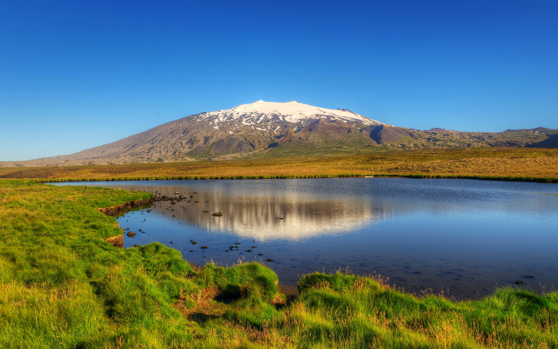
Snæfellsjökull
As previously mentioned, the Peninsula is most known for Snæfellsjökull, a glacier-capped volcano which can also be seen from Reykjavik on a very clear day. The glacier stands at around 1,445 metres tall and beneath the glacier is a 700,000-year-old volcano.
Snæfellsjökull is usually covered in snow year round, however, in 2012 the snow and Ice had disappeared, leaving locals fearing that climate change was having a huge impact on the glacier.
Established as a National Park in 2001, the Snæfellsjökull National Park has a rich history, with many tales and stories of the area being passed down through the years.
Probably the most unusual story isn't actually that old, 1993 in fact. Snæfellsjökull had attracted thousands of people after some paranormal enthusiasts believed that alien lifeforms would be landing on the glacier. This announcement had spread like wildfire with many major news channels picking up on the story. In fact, CNN even showed up with a camera crew, though everyone was left disappointed as typically, the aliens failed to show.
Many of you may also know Snæfellsjökull from being featured in the Ben Stiller movie, 'The Secret Life of Walter Mitty'.
Gerðuberg
The next prominent feature of the Snæfellsnes Peninsula is probably the Gerðuberg Basalt Cliffs, which are a row of perfectly shaped hexagonal basalt columns that run along the edge of a cliff. The columns run for just over one kilometre and the columns range from seven to 14 metres long.
The reason for Gerðubergs popularity is that somehow the basalt columns are perfectly shaped, almost as if they were created by an artist. They were created following an eruption when the lava ran off the edge of the cliff, the area was then cooled by the sea and so the basalt columns you see today were left.

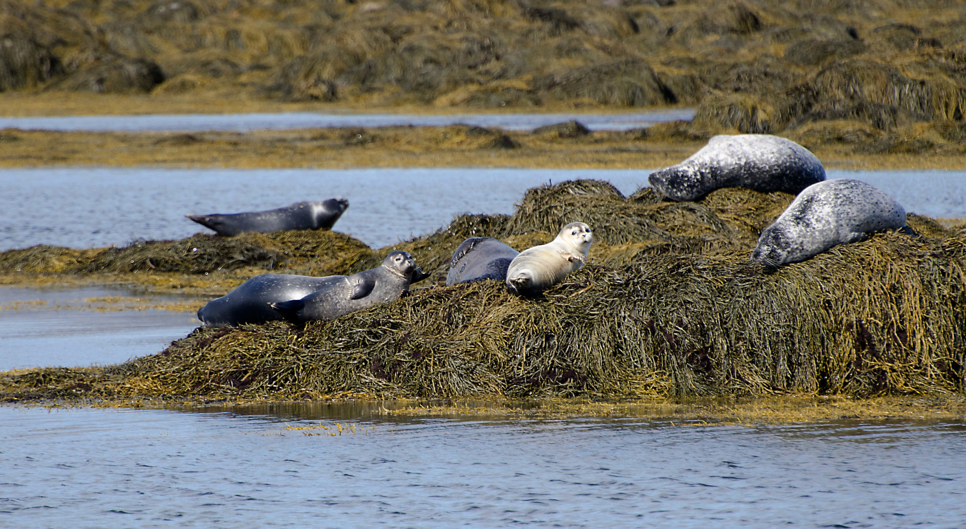
There are also many popular beaches in the area, with the most-popular being Ytri-Tunga. This beach has gained popularity due to the high chances of seeing seals and also the fact that, unlike most other beaches in Iceland, the sand is golden.
Ytri-Tunga is located right next to a farm (which also has the same name) just off of the main road through the Snæfellsnes Peninsula.
The next most popular beach is Djúpalónssandur, this beach is a black-sand beach and is surrounded by dark cliffs and rugged land. Similarly to Reynisfjara Beach, the sea can be very unpredictable and 'sneaker waves' can lead to disastrous consequences. So, be very careful if you intend on going close to the water.
One of my favourite spots in Snæfellsnes is Rauðfelsdsgjá (Red Mountain Rift), which is a beautiful gorge located in the Botnsfjall Mountain. To get there, park at the car park then follow the trail that leads alongside a stream. It is also possible to climb further into the gorge where you will meet a small waterfall, though this is only accessible if you are physically fit and trust your hiking/climbing capabilities. You will also get pretty wet, as will the pathway, so be careful not to slip.
Situated close by to Rauðfelsdsgjá, you can find the Lóndrangar basalt cliffs. They are 2 huge pillars upon a cliff, one standing at 75 metres and the other 61 metres. Lóndrangar is referred to as 'The Rocky Castle'. To get to them, you pass the visitors centre and then walk through a lava field. It is asked that people treat this area with care (as always) as local farmers believe that numerous Elves live in the cliffs.

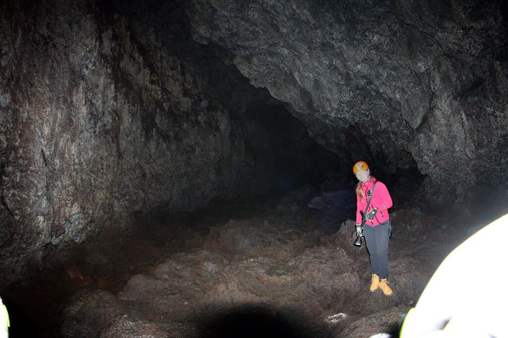
The Snæfellsnes Peninsula is also home to 2 popular lava caves. The most known is Vatnshellir as it is easily accessible and possesses some stunning colours inside. However, there is also Sönghellir , or the Singing Cave, named for its great echoing chamber.
Anyone can pay to get into Vatnshellir, however, you will need to be part of a guided tour in order to access Sönghellir.
The Snæfellsnes Peninsula has many attractions, to the point that a book could be written detailing all of them. The attractions mentioned above are the most popular and also my favourite, below I will list some of the others that you will find in the area.
As well as the attractions, there are also some great towns which you may want to visit. These include Ólafsvík (check out the restaurant 'Hraun', they serve some great fish soup!), Hellissandur, Stykkishólmur, Hellnar, and Arnarstapi.
As mentioned before, most people will tend to spend one day in the area, however, there is so much to do and see that you could even spend your entire trip there and not be disappointed.
____
Related Posts